Nikki Learns about Symbols and a Key
People who make maps (cartographers) use symbols to represent things on the ground. For example, in a map of a city, mapmakers will not draw a separate picture of every school. Instead, they will probably draw a simple picture of a school and use that to show every school on the map.
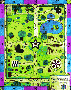
Look at this map of the park again. Colors are also used to show things on a map.
Rivers and lakes are usually shown as blue.
Trees, shrubs, and grass are usually shown as green.
Buildings and streets are shown as black or white.
Now you know that symbols on a map represent something on the ground.
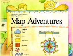
When you look at a map, you may not know what all its symbols mean. So, on a map, symbols are identified in an area called the key or the legend.
A map's key or legend explains what symbols on a map mean.
Here is a key for the map above.
When you look at a map, you may not know what all its symbols mean. So, on a map, symbols are identified in an area called the key or the legend.
A map's key or legend explains what symbols on a map mean.
Here is a key for the map above.
Thanks to the United States Geological Survey for the information and materials found on this site.

